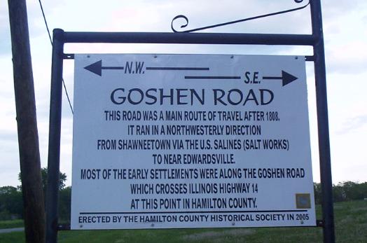
The Goshen Road was an early road that ran from Old Shawneetown, Illinois, on the Ohio River, northwest to the Goshen Settlement, near Glen Carbon, Illinois, near the Mississippi River. In the early 1800's, this was the main east/west road in Illinois.
The Goshen Road started as a natural, or pioneer, trace: a route that was used by Native Americans and migrating animals. The road was not a definite, marked out path. It was, rather, a collection of vague, parallel paths that crossed, shifting with the season and over the years.
Beginning around 1800, the Illinois Territory was surveyed pursuant to the Land Ordinance of 1785. Because this survey as aimed at establishing the Township and Section boundaries, the surveyors were not paid for mapping roads. However, many did show the locations of roads. Because the Goshen Road was often the only noteworthy feature at the time of the original survey, the road was noted in many of these surveys. Because these surveys marked only the Section boundaries, we often have an accurate location of the road only at one-mile intervals.
The Goshen Road generally followed the Saline River watershed in a northwesterly direction until it met the Big Muddy River/Saline River divide, which was also the Mississippi River/Ohio River divide. It then followed that divide in a northwesterly direction, avoiding a crossing of the swamps around the Big Muddy River. The road finally crossed the Big Muddy watershed in northern Jefferson County. The road then crossed the Kaskaskia Bottoms, which could not be avoided, on a fairly direct line toward the Goshen Settlement, in the Glen Carbon area.
Some sources say the road was built in 1809. There are, however, indications that it existed before that time